Different Spectral Domain Transformation for Land Cover Classification Using Convolutional Neural Networks with Multi-Temporal Satellite Imagery
Junghee Lee, Daehyeon Han, Minso Shin, Jungho Im, 이정혜, Lindi J. Quackenbush (2020) · remote-sensing 12:1097 · DOI ↗
1D spectral vector 를 2D 이미지 로 변환하는 4 가지 방법 (Polygon graph, Line graph, 2D Matrix, 1D vector) 을 convolutional-neural-network 에 입력해 land cover 분류 성능을 체계적으로 비교한다. Landsat 8 다중시기 영상 + 3 개 지역 (Lake Tapps WA, Concord NH, Gwangju Korea) × 9 land cover class. CNN-Polygon 이 작은 sample (<200/class) 영역 에서 일관되게 우월하며 (Friedman test, p<10⁻⁶), sample 이 커지면 CNN-Matrix·CNN-1D 가 비등 또는 우월해진다. occlusion-map 기반 sensitivity 로 class 별 결정적 band 식별.
- RQ: 1D spectral vector 를 어떤 2D 변환 (polygon vs line vs matrix vs patch) 으로 CNN 에 입력해야 land cover 분류 정확도가 최대화되는가? Sample size 가 작을 때 / 클 때 최적 변환은 어떻게 달라지는가?
- 방법론: convolutional-neural-network, spectral-domain-transformation (polygon · line · matrix · patch), random-forest, support-vector-machine, occlusion-map, friedman-test, wilcoxon-signed-rank-test
- 데이터: Landsat 8 OLI 4 계절 영상 × 3 지역 (Lake Tapps 1,575 train pts · Concord 1,490 · Gwangju 3,600 train), 7 spectral bands × 4 seasons = 28 input vars, 9 land cover classes (barren · cropland · grassland · water · evergreen · mixed · deciduous · high impervious · low impervious)
- 주요 발견: (1) Original sample (
150200/class): CNN-Polygon 평균 rank 1.00 (Lake Tapps OA) · 1.25 (Concord OA), 모든 비교 모형 압도 (Friedman p=1.29×10⁻⁷). (2) Oversampled (1,000/class): CNN-Polygon 우위 약화, Matrix 가 Concord 에서 평균 rank 1.40 으로 역전. (3) Gwangju undersampling: 50 samples/class 에서 CNN-Polygon rank 1.2 압도, 400 samples 에서 CNN-1D rank 1.30 으로 역전. (4) CNN-Patch (11×11 neighbor) 는 small sample 에 가장 약함 (rank 6.95) — patch 다양성에 large sample 필요. (5) occlusion-map 으로 class 별 결정적 band 식별 — NIR (band 5) 가 산림 분류에 결정적. - 시사점: 위성 영상 분류에서 reference data 수집이 제약 (수작업 visual interpretation 의 high cost) 인 환경에 polygon graph CNN 권장. 시각적 직관성 을 부여하는 representation 이 작은 sample 에서 generalize 잘 됨 — feature engineering 가 deep architecture 보다 우선.
요약
이 paper 는 이정혜 의 원격탐사 + 머신러닝 라인의 핵심 milestone — Kim et al. (2018) 의 line-graph CNN (Convolutional Neural Network-Based Land Cover Classification Using 2-D Spectral Reflectance Curve Graphs With Multitemporal Satellite Imagery) 첫 제안을 체계적 비교 실험 으로 발전시킨다. 기존 land cover CNN 문헌은 (i) U-Net · FCN 같은 architecture 변형, (ii) patch-based input (3×3, 11×11 neighbor) 의 두 갈래였고, 1D spectral vector 를 어떻게 2D 로 reshape 할지 의 input representation 자체가 비교된 적이 없었다. 이 paper 는 그 빈자리를 4 변환 × 3 지역 × 3 sample-size 시나리오 의 grid 로 채운다.
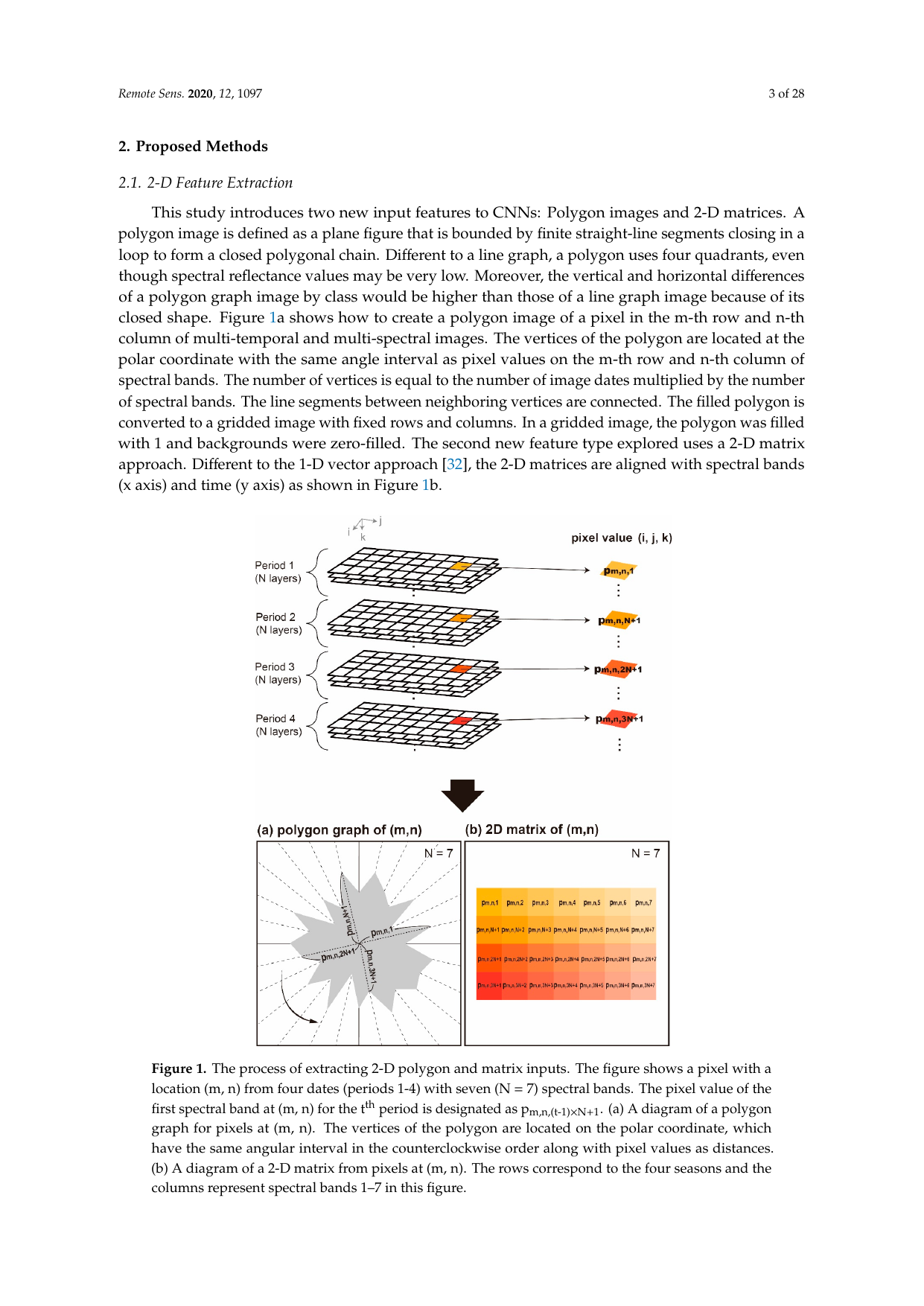
방법론 핵심은 두 새로운 input 표현이다. (1) CNN-Polygon — 28 개 reflectance 값을 polar coordinate 의 꼭지점으로 두고 (각도는 일정 간격) closed polygon 으로 연결, 100×100 binary grid 로 rasterize. (2) CNN-Matrix — 4 season × 7 band 의 2D matrix 직접 input (4×7). 비교군: CNN-Line (Kim et al. 2018), CNN-1D (lee-2018-1d-cnn 구조), CNN-Patch (11×11×28), random-forest (500 trees), support-vector-machine (linear, C=100). CNN-Polygon architecture: 3 conv (32→64→128 filters, 5×5→3×3) + max-pool + dropout 0.25 + FC (256→16→9). 다중-class softmax + categorical cross-entropy, Adam (lr=0.001). 통계 비교는 10 회 random split 의 friedman-test (multi-model) 와 wilcoxon-signed-rank-test (pairwise) — non-parametric 으로 정규성 가정 회피.
핵심 발견 두 가지가 정량적으로 강력하다. 첫째, 작은 sample regime (50200/class) 에서 CNN-Polygon 의 평균 rank 가 1.001.65 로 일관되게 최상위, Friedman p 가 10⁻⁶10⁻⁸ 로 매우 유의. 둘째, 큰 sample regime (oversampled 1,000/class, 또는 Gwangju 400/class) 에서는 CNN-Matrix 또는 CNN-1D 가 rank 1.401.30 으로 역전 — 시각적 redundancy 가 large-data 환경의 학습 효율을 떨어뜨림. CNN-Patch 는 모든 small-sample 시나리오에서 worst rank (6.80~6.95) — neighbor 다양성 을 학습하려면 patch 당 큰 sample 필요. occlusion-map sensitivity 로 각 class 의 결정적 band 식별: 산림 (NIR), 도시 (SWIR), barren vs high impervious 의 spectral 혼동 해소 케이스 분석. 정책 함의는 reference data 수집 비용이 높은 개발도상국·재난 상황 의 land cover 분류에 polygon CNN 의 sample-efficiency 이점이 직결된다는 것. 한계: (i) polygon 의 각도 ordering (band 순서) 이 임의 결정, (ii) CNN-Matrix·CNN-1D 의 large-sample 우위의 구조적 원인 미규명, (iii) patch 모형의 stride·architecture 의 추가 tuning 여지 미탐색.
핵심 결과
| 시나리오 | 지역 | sample/class | 최상위 모형 (rank) | OA |
|---|---|---|---|---|
| Original | Lake Tapps | ~178 | CNN-Polygon (1.00) | ~93-95% |
| Original | Concord | ~165 | CNN-Polygon (1.25) | ~93-95% |
| Oversampled | Lake Tapps | 1,000 | CNN-Polygon (1.65) | ~94% |
| Oversampled | Concord | 1,000 | CNN-Matrix (1.40) | ~94% |
| Undersampled | Gwangju | 50 | CNN-Polygon (1.20) | 71.43% |
| Undersampled | Gwangju | 100 | CNN-Polygon / CNN-1D tie (1.80) | ~78% |
| Undersampled | Gwangju | 200 | CNN-Polygon (1.65) | 80-84% |
| Undersampled | Gwangju | 400 | CNN-1D (1.30) | 82.06% |
| Undersampled | Gwangju | 50 | CNN-Patch (worst: 6.95) | low |
Friedman p-values 모두 10⁻⁴ ~ 10⁻⁸ 로 모형 차이가 통계적으로 유의. CNN-Polygon 의 평균 OA: Concord/Lake Tapps 9395%, Gwangju 8084%.
방법론 노트
convolutional-neural-network 은 image input 에 강력하지만 land cover 분류의 본질은 pixel-level spectral signature — 1D vector 다. 이 paper 는 1D 를 image-like 2D 로 변환 함으로써 CNN 의 convolutional inductive bias (translation invariance, locality) 를 차용한다. 변환 자체가 class signature 의 시각적 분리 를 강화하면 small-sample 일반화가 좋아진다는 가설.
핵심 식. Polygon graph 변환: pixel 에서 multi-temporal-multispectral reflectance (, ) 가 polar coordinate 의 꼭지점이 된다.
이웃한 가 line segment 로 연결되어 closed polygon. Polygon 내부는 1, 외부는 0 으로 채워 100×100 binary image . CNN forward:
with cross-entropy loss .
식별 / 평가 전략: (i) 10 회 random 80:20 split 으로 small-dataset test bias 완화, (ii) Oversampling = 원 training 에 ±5% reflectance perturbation 으로 1,000/class 까지 증강, (iii) occlusion-map = 7×7 zero-fill window 를 image 위 sliding 시키며 accuracy drop 측정, normalize 후 class 별 sensitivity heatmap.
연구 계보
직접 predecessor 는 (i) Convolutional Neural Network-Based Land Cover Classification Using 2-D Spectral Reflectance Curve Graphs With Multitemporal Satellite Imagery (Kim et al. 2018, Remote Sensing of Environment) — line graph CNN 의 첫 제안, 본 paper 의 method 출발점, (ii) Sharma et al. (2017), Hu et al. (2018) 의 patch-based land-cover CNN literature, (iii) Zeiler & Fergus (2014) 의 occlusion-based CNN visualization, (iv) Demšar (2006), García & Herrera (2008) 의 non-parametric multi-classifier 비교 protocol. 이정혜 의 원격탐사 + 머신러닝 라인 (이정혜 author page) 안에서 Kim et al. (2018) 의 conceptual proposal 을 quantitative validation + 4 변환 비교 로 발전시킨 sibling. UNIST Jungho Im 의 remote-sensing 그룹과의 협업이 이 라인의 institutional anchor.
See also
- 이정혜
- Jungho Im
- Junghee Lee
- Convolutional Neural Network-Based Land Cover Classification Using 2-D Spectral Reflectance Curve Graphs With Multitemporal Satellite Imagery
- convolutional-neural-network
- spectral-domain-transformation
- occlusion-map
- land-cover-classification
- remote-sensing
인접 그래프
- 인물 6
- 방법론 1
- 논문 1